Help topics
- Purpose of the site
- Adjusting the Ordnance Survey Maps Compass
- Browser Support
- Compass features
- Compass or GPS - pros and cons for navigation
- Compass Test
- Draw Single Leg Route
- Extending the compass direction of travel arrow
- False readings when using a compass
- Fine Tuning the Ordnance Survey Maps Compass
- Getting Started with Ordnance Survey Maps Compass
- Google Compass
- GPS or Compass - which is best for navigation?
- Grid references test
- Helpful Tips
- How to use a compass
- Import Routes
- Latitude and longitude positions: degrees, minutes and seconds
- Magnetic declination or variation
- Magnetic declination or variation adjustment
- Magnetic declination or variation calculation
- Map projections
- Map reading
- Map reading skills test
- Map symbols
- Menu
- Moving and Manipulating the Ordnance Survey Maps Compass
- Multi legged Routes
- My Ordnance Survey Compass Map Routes
- Negative magnetic declination or variation
- New Features
- North: different types
- Open Routes
- Ordnance Survey maps projection
- Panning and Zooming with Ordnance Survey Maps Compass
- Positive magnetic declination or variation
- Print Map Function
- Privacy policy
- Resizing the compass direction of travel arrow
- Route information
- Safety
- Save and Store Map Routes
- Single leg or multi-legged routes?
- Single Leg Route
- Stored Map Routes
- Test your compass reading skills
- Tips
- Types of bearings used in navigation
- Updates
- User Guide
- Watch as Compass
- What is a compass?
- What type of compass is used on the site?
- Zooming with Ordnance Survey Maps Compass
- Disclaimer
- Credits and Licence Agreement
Compass Features

The following diagram shows a compass and explains its various features.

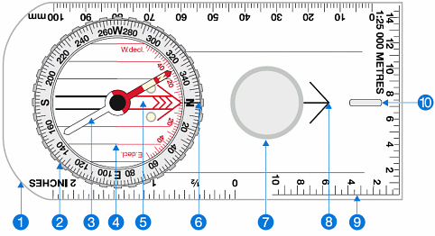
- 1. The base plate mounting of the compass, with a ruler for measuring scale.
- 2. The compass housing contains the magnetic needle and has the points of the compass printed on a circular, rotating bezel.
- 3. The compass needle floats on liquid so it can rotate freely, the red end should always point to magnetic north.
- 4. Orienting lines fixed within the compass housing and designed to be aligned with the vertical grid lines on a map. Half the lines are coloured red to indicate north.
- 5. Orienting arrow fixed within the compass housing, aligned to north on the housing.
- 6. The index line fixed within the outer edge of the compass housing as an extension of the direction of travel arrow. It marks the bearing you set by rotating the compass housing.
- 7. Magnifier for detailed map reading.
- 8. The direction of travel arrow shows the direction that you want to travel along or the bearing you are taking. It is fixed parallel to the sides of the base plate and aligned with the fixed index line on the edge of the compass housing (number 6).
- 9. Compass scale displayed along the edge of the base plate so you can measure distances on maps.
- 10. Luminous strip to assist navigation at night.
Copyright © 2011-2023 All Rights Reserved
Barcelona Field Studies Centre S.L.