Help topics
- Purpose of the site
- Adjusting the Ordnance Survey Maps Compass
- Browser Support
- Compass features
- Compass or GPS - pros and cons for navigation
- Compass Test
- Draw Single Leg Route
- Extending the compass direction of travel arrow
- False readings when using a compass
- Fine Tuning the Ordnance Survey Maps Compass
- Getting Started with Ordnance Survey Maps Compass
- Google Compass
- GPS or Compass - which is best for navigation?
- Grid references test
- Helpful Tips
- How to use a compass
- Import Routes
- Latitude and longitude positions: degrees, minutes and seconds
- Magnetic declination or variation
- Magnetic declination or variation adjustment
- Magnetic declination or variation calculation
- Map projections
- Map reading
- Map reading skills test
- Map symbols
- Menu
- Moving and Manipulating the Ordnance Survey Maps Compass
- Multi legged Routes
- My Ordnance Survey Compass Map Routes
- Negative magnetic declination or variation
- New Features
- North: different types
- Open Routes
- Ordnance Survey maps projection
- Panning and Zooming with Ordnance Survey Maps Compass
- Positive magnetic declination or variation
- Print Map Function
- Privacy policy
- Resizing the compass direction of travel arrow
- Route information
- Safety
- Save and Store Map Routes
- Single leg or multi-legged routes?
- Single Leg Route
- Stored Map Routes
- Test your compass reading skills
- Tips
- Types of bearings used in navigation
- Updates
- User Guide
- Watch as Compass
- What is a compass?
- What type of compass is used on the site?
- Zooming with Ordnance Survey Maps Compass
- Disclaimer
- Credits and Licence Agreement
Extending the Compass direction of travel arrow

The minimum route leg distance currently available at the maximum contour line zoom level using the Ordnance Survey Maps Compass is approximately 0.39 miles (63 metres). Increasing the route leg distance at this zoom level requires the extension of the direction of travel arrow and assists in obtaining a more accurate bearing as well as recording an accurate distance for the route leg.
There are two methods available for extending the Compass direction of travel arrow: manually and using a slider. Both options are provided in the left-hand menu and are illustrated below.
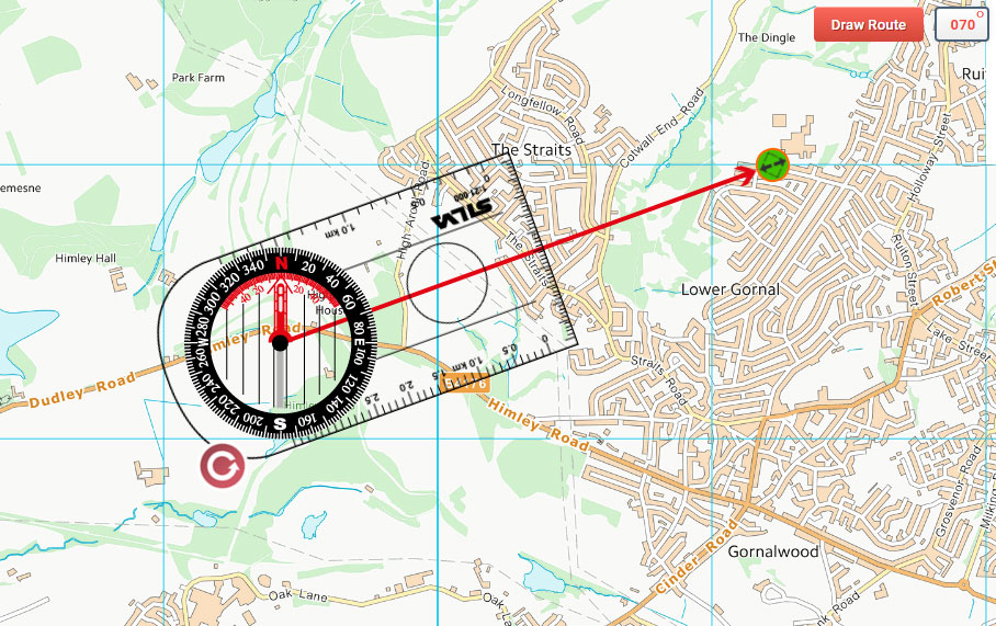
Direction of Travel Arrow Manual Resize
Drag the compass so that its centre sits on top of your starting point. Select Resize Arrow Manually from the menu and a green circle appears at the end of the red Direction of Travel arrow on the compass. Adjust the length of the arrow by dragging the green circle. When it is at your desired destination, click the End Resizing button. Click the Draw Route button that then appears at the top right of the map.
Manual extension of the Ordnance Survey Maps Compass direction of travel arrow
Copyright © 2011-2023 All Rights Reserved
Barcelona Field Studies Centre S.L.