Ordnance Survey Maps Compass Preview and Print Map Function

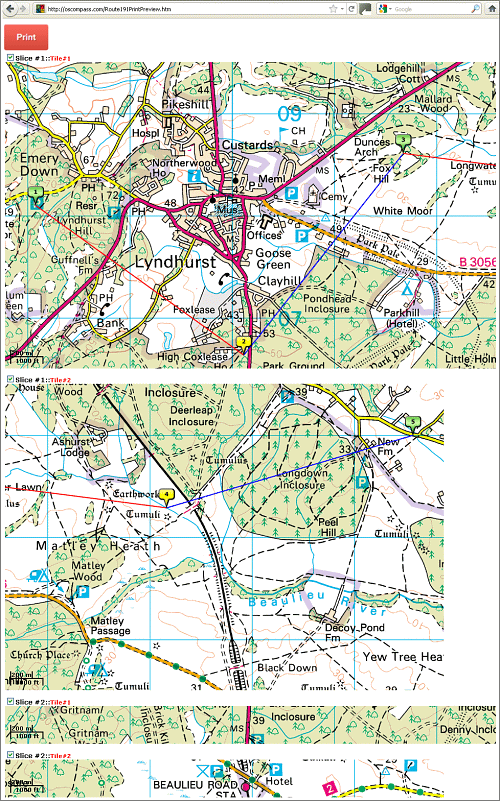
This function previews and prints large Ordnance Survey route maps by automatically centreing the map on the plotted route(s) and cropping the map into horizontal 'slices' which are then further cropped into printable 'tiles'. This overcomes the common failure of printers to handle large images, particularly map areas that lie outside of the immediate screenshot. To retain detail, the printable map is not reduced in size or resolution.
How is the size of each slice defined?
The maximum slice width is 960PX and the maximum height is 600PX. The Print Map function will try to create the slice with this width and height and if there is not enough space in the image, it will crop up to the end of the image width and height.
Changing Print Resolution
The Print resolution is controllable from the user end (Printing settings). The Google Compass Print Map function gives the user printable slices in the same Google Maps resolution without shrinking the image width/height. We recommend a printer setting quality of 300 dpi or higher for best print results.
Changing Printer Layout to Landscape Orientation
Landscape page orientation is where the page is turned sideways, so the horizontal dimensions are longer than the vertical. Printers are programmed to print in 'Portrait Orientation' by default, with text printed lengthways down a page orientated with its vertical dimensions longer than the horizontal. Since the printable map tile horizontal widths are greater than their heights (960PX * 600 PX), we recommend that users select 'Landscape Orientation' from their Printer Preferences options.
Example An online Ordnance Survey Maps Compass route example shows a four-legged route 1-2, 2-3, 3-4, and 4-5, where the Print Map function has automatically cropped the route into four printable slices or tiles. To print, this example should first be imported as Route ID 191: Ordnance Survey Maps Compass Print Preview Example. Option boxes appear next to each map segment, allowing printing to be deselected if not required.
Tip
If the Print Preview window does not appear, you will need to disable your browser popup blockers for this site.
How is the size of each slice defined?
The maximum slice width is 960PX and the maximum height is 600PX. The Print Map function will try to create the slice with this width and height and if there is not enough space in the image, it will crop up to the end of the image width and height.
Changing Print Resolution
The Print resolution is controllable from the user end (Printing settings). The Google Compass Print Map function gives the user printable slices in the same Google Maps resolution without shrinking the image width/height. We recommend a printer setting quality of 300 dpi or higher for best print results.
Changing Printer Layout to Landscape Orientation
Landscape page orientation is where the page is turned sideways, so the horizontal dimensions are longer than the vertical. Printers are programmed to print in 'Portrait Orientation' by default, with text printed lengthways down a page orientated with its vertical dimensions longer than the horizontal. Since the printable map tile horizontal widths are greater than their heights (960PX * 600 PX), we recommend that users select 'Landscape Orientation' from their Printer Preferences options.
Example An online Ordnance Survey Maps Compass route example shows a four-legged route 1-2, 2-3, 3-4, and 4-5, where the Print Map function has automatically cropped the route into four printable slices or tiles. To print, this example should first be imported as Route ID 191: Ordnance Survey Maps Compass Print Preview Example. Option boxes appear next to each map segment, allowing printing to be deselected if not required.

Google Compass Print Preview Example
| Width (PX) | Height (PX) | |
| Slice #1 | 1500 | 600 |
| Slice #1 Tile#1 | 960 | 600 |
| Slice #1 Tile#2 | 540 | 600 |
| Slice #2 | 1500 | 200 |
| Slice #2 Tile#1 | 960 | 200 |
| Slice #2 Tile#2 | 540 | 200 |
If the Print Preview window does not appear, you will need to disable your browser popup blockers for this site.